
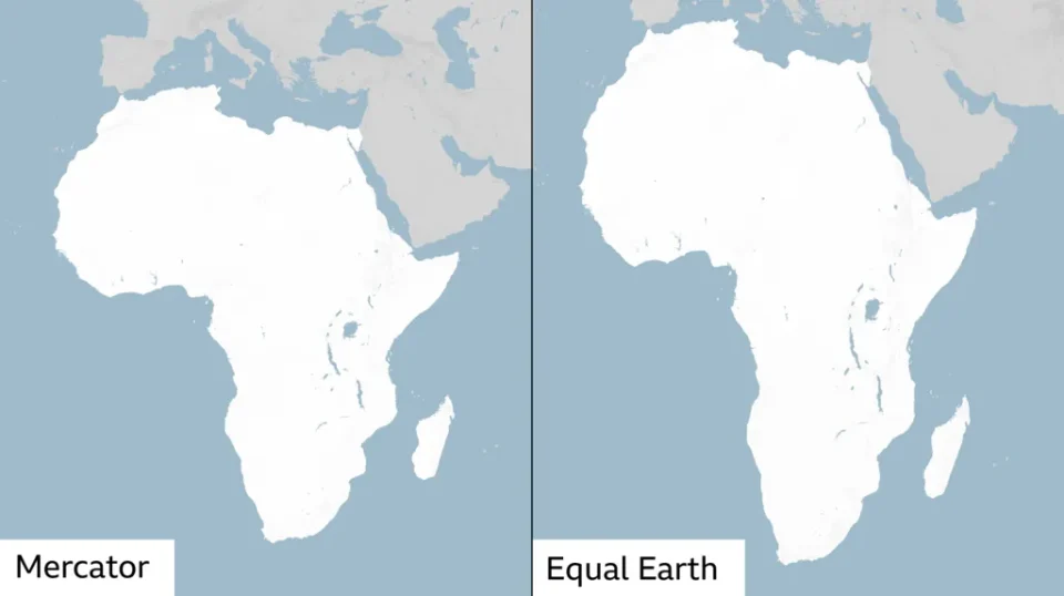
A global campaign to redraw the way Africa is represented on world maps has secured a major victory at the United Nations, after 164 countries backed a resolution calling for the adoption of maps that better reflect the true size of the continents.
The resolution, known as “Correct the Map”, was sponsored by Togo and supported by members of the African Union. France and the UK were among those that voted in favour, while the United States was the only country to oppose the measure. Six countries abstained.
Although the UN General Assembly resolution is non-binding, supporters say the vote could influence the maps used by governments, schools and institutions around the world.
At the centre of the campaign is the Mercator projection, a map that has shaped how generations have visualised the world since it was created in the 16th Century.
The projection has long faced criticism because of the way it distorts the relative size of land masses. Africa, for instance, appears much closer in size to Greenland on the map, despite being about 14 times larger.
Campaigners argue that such distortions are not merely a technical issue. They say the way continents are portrayed can influence how people understand their importance, resources, populations and economic potential.
The Mercator projection was developed in 1569 by Flemish cartographer Gerardus Mercator, primarily to assist European navigators. Its distortions stem from the difficulty of transferring the curved surface of the Earth onto a flat, two-dimensional map.
No world map can represent a spherical planet on a flat surface without making some compromises. The Mercator projection preserves direction and makes navigation easier, but that comes at the expense of accurate representation of area.
Under the projection, regions closer to the equator appear smaller, while land masses closer to the North and South Poles are enlarged.
Efforts to address the problem have produced alternative projections, including the Equal Earth map, developed by a group of cartographers in 2018. Unlike Mercator, the projection is designed to preserve the relative areas of continents and countries.
The African Union’s 54 member states adopted the Equal Earth projection in February, saying it “more accurately represents the sizes of all continents, particularly Africa”.
The campaign has also gained traction online. The group #CorrectTheMap said: “You could fit the United States, China, India, Japan, Mexico and much of Europe into Africa and still have land to spare.”
Togo has emerged as one of the strongest advocates for changing the way the world is mapped. Ahead of Friday’s UN vote, Togolese Foreign Minister Robert Dussey told the Reuters news agency: “A fair world begins with a fair map.”
He had earlier told a UN briefing: “A map is never neutral. It shapes perceptions, influences how the place of peoples and continents in the world is understood.”
Dussey’s campaign received support from French Foreign Minister Jean-Noël Barrot, who said his ministry would stop using the Mercator map.
“Changing the map obviously doesn’t change the world. But correcting a representation that distorts it is already an act of truth,” he said.
The proposal, however, faced opposition from Washington. Yaryna Ferencevych, a US representative at the UN, accused the General Assembly of diverting its attention from more pressing global concerns.
“Instead of focusing on genuine problems of international peace, prosperity, or good relations, this body is debating map projects from the 16th Century, and their role in promoting reparations and ‘cognitive justice’,” she said.
The disagreement comes amid wider tensions over how the UN addresses historical issues involving Africa. In March, the US also criticised a resolution that described the transatlantic slave trade as “the gravest crime against humanity”.
For supporters of the map campaign, however, the issue goes beyond cartography.
“Africa’s misrepresentation on world maps is not just a cartographic error – it’s a narrative issue,” Lerato Mogoatlhe from Africa No Filter, one of the groups behind the campaign to ditch the Mercator map, told the BBC.
She said the campaign formed part of efforts to challenge what she described as the “world’s longest misinformation and disinformation” about Africa.
Kenyan geographer Kioko Muendo similarly argued that the visual treatment of Africa has consequences beyond classrooms and atlases, saying it has helped obscure the continent’s scale and possibilities.
“Maps are more than just guides for travellers – they shape how regions are perceived politically and economically,” he told the BBC.
